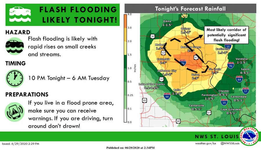

The National Weather Service has issued a flash flood watch for St. Louis County and surrounding areas ahead of heavy rains expected the next several nights.
The watch will be in effect from 7 p.m. Monday night through Wednesday morning, with heavy rains expected Monday night through Tuesday morning that could drop as much as 6 inches of rain in some areas close to St. Louis County, the NWS in St. Louis said.
St. Louis itself is currently expected to receive between 2-3 inches of rain tonight through Tuesday morning.
“Tonight could become a serious situation for some folks,” the NWS in St. Louis tweeted Monday.
A flash flood watch means that conditions will be favorable for flash flooding. The National Weather Service said Monday night’s rain will “likely” lead to flash flooding.
Dangerous flash flooding could happen near creeks and streams, the weather service cautioned.
Authorities are also reminding everyone not to drive through any amount of water and “turn around, don’t drown.” It only takes 12 to 18 inches of water for cars, trucks and SUVs to start floating.
The counties affected in Missouri by the flash flood watch are St. Louis County, St. Louis city, St. Charles, Franklin, Pike, Warren, Lincoln, Gasconade, Audrain, Boone, Callaway, Cole, Knox, Lewis, Marion, Moniteau, Monroe, Montgomery, Osage, Ralls and Shelby counties.
In Illinois, the closest counties affected are Madison, Bond, Fayette, Jersey, Macoupin, Montgomery, Pike, Adams and Greene.