


JEFFERSON CITY – A congressional redistricting map was passed by both branches of Missouri’s legislature Wednesday night, ending week-long stalemate between House and Senate.
Like the earlier versions passed by the House and Senate, the map heading to Gov. Jay Nixon’s desk eliminates the St. Louis city district of U.S. Rep. Russ Carnahan, D-St. Louis.
In an unusual move, the House and Senate rushed signing the bill and officially delivering it to the governor in order to force Jay Nixon to sign or veto the bill before the legislature’s regular session adjourns May 13.
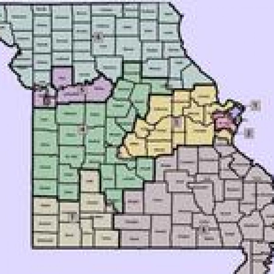
The final plan puts a large chunk of St. Charles County in one congressional district. The map also splits Jefferson County into three different congressional districts. Opposition between the House and Senate stemmed from the dispute over these two counties in the St. Louis area.
The Senate, with both its majority leader and its redistricting committee chair from St. Charles, had been pushing a plan that gave the county a larger voice in the congressional district of Cong. Blaine Luetkemeyer, R-St. Elizabeth.
Rep. Todd Akin, R-Town and Country, told reporters last week that the Missouri GOP delegation was in support of the House version of the plan.
The House Redistricting Committee chair — Rep. John Diehl, R-Town and Country, credited the compromise to a willingness by both chambers to override a potential gubernatorial veto before the end of session.
“We thought today was a deadline of sorts and that triggered some discussions with our Senate counterparts,” Diehl said of the Wednesday deadline for assuring the governor had to act on the bill before the end of the legislative session.
The compromise addressed the splits in St. Charles County by putting 134,000 people in a district with St. Louis County and 225,000 in the district held by Luetkemeyer. The map also put 44,000 Jefferson County residents into a district the includes St. Louis County while placing 114,000 in Luetkemeyer’s district. The remaining 60,000 Jefferson County residents are in the district held by Cong. Jo Ann Emerson, R-Cape Girardeau.
In order to pass the map Wednesday, the House had to suspend a rule that requires a conference committee report be delivered to the chamber desks of lawmakers at least one day before a vote. Majority Leader Rep. Tim Jones, R-St. Louis County, said it was vital to address this issue before the end of session. Minority Floor Leader, Rep. Mike Talboy, D-Kansas City, was opposed to the rule suspension.
“We are going to suspend the rules because we want to make it easier for people. Seems to me it should be upheld at whatever inconvenience that might cause,” Talboy said.
Jones’ motion prevailed and the House ultimately passed the map with 96 “yes” votes. The vote was 13 shy of the number needed to override a potential veto from the governor.
House leaders, however, expressed confidence they had the votes to override if the governor were to veto the plan.
“I think at the end of the day Republicans will be on board and we will see how many Democrats we have on board,” said House Speaker Rep. Steven Tilley, R-Perryville.
Tilley, however, said he expects the governor to take a serious look at the map.
“I am going to encourage the governor the next time I visit with them to look at the map and look how it is drawn and encourage him to sign it,” Tilley said.
Three House Democrats — two black members from St. Louis city and one from Kansas City — voted in support of the plan that retains strong Democratic majorities in the districts of Missouri’s two black Congress members — Rep. Lacy Clay, D-St. Louis, and Rep. Emanuel Cleaver, D-Kansas City. Clay’s district would have a 49.5 percent black population while Cleaver’s would have a 22 percent black population according to data provided by legislative staff Wednesday night.
In the Senate, the plan got a larger Democratic vote including support from the Senate Democratic leader, Victor Callahan, D-Jackson County.
Six House Republicans and two Senate Republicans voted against the plan. Some rural Republicans had complained about having their rural areas included into districts with different economic interests or cultural backgrounds.
Sen. Bill Stouffer, R-Napton, objected to his part of his district being included in the urban Kansas City district currently represented by Cleaver. Despite congressional involvement throughout the process, Diehl and Rupp said they had spoken to any member of Congress today. Under the map Columbia would be placed in the district currently held by Cong. Vicky Hartzler, R-Harrisonville.
Sen. Ryan McKenna, D-Jefferson County, opposed the map and said it was unfair to his county.
“What matters to me is being represented by three congressional people,” McKenna said.
After the Senate vote, both the House Speaker and the Senate President Pro Tem signed the bill so it could be delivered to the governor Wednesday night.